
Savvy Navvy's seven years of making boating more accessible
by Mark Jardine 21 Oct 2024 12:00 BST
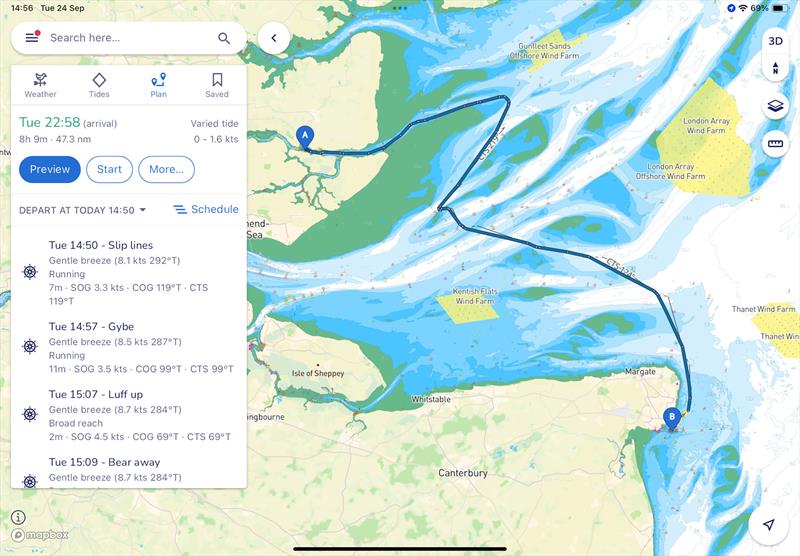
Course planning on the east coast of the UK with times and directions © savvy navvy
The rise of Savvy Navvy in the world of boating navigation has been spectacular, with over 2 million downloads of the app.
To find out more, I spoke to founder Jelte Liebrand about his background, philosophy, the app itself and how it works, plus what is in development.
Savvy Navvy is still very young in the world of navigation, when you compare it to the established brands, yet has a user base which is equal to any, which Jelte described as 'humbling and amazing'. In many ways though this shouldn't come as a surprise, especially when you look at his background, where he worked for Google.
Mainstream tech brands can have meteoric growth, so he knows the business model and has the clearly defined mission of creating 'the Google Maps for Boats'.
As soon as you open the Savvy Navvy app it will feel familiar to anyone who uses Google Maps. The layout, the functionality and the user interface are intuitive, which is exactly as it should be.
Jelte summed up his reasoning for that familiarity perfectly, "Ultimately the idea started with helping people to feel less intimidated when they get out on the water - they need to be in an environment where things just make sense. On the water that's even more important because the last thing you want to do, especially if it gets a bit hairy, is say 'How do I use this? Where's the manual? What do I need to do?'. You need to immediately understand what is needed, which buttons you need to press, or which gestures you do to get to the information that you need."
Just as Google Maps is updated continually with traffic levels, accidents and road works, Savvy Navvy is kept up-to-date with weather, tides and hazards. In a car you are essentially restricted to the roads, whereas out on the water you can go 360 degrees as long as there is water. Having all the information to hand on, for example, shallows or rocks, is vital.
When it comes to routing, the Savvy Navvy app is continually updating your course, taking into account tides, wind and the forecast wind and can give you a dynamic ETA for your destination. Then it can go a stage further, as Jelte described, "Maybe we might tell you to turn the engine on if you're sailing, or throttle up a little bit more if you're on a motorboat, because you need to get past a tide gate at a certain point in time. All of this we can do offline on your device because, similar to Google Maps, we download data in the background - the charts, the weather, the tides, everything you need - so that while you're out there, we can give you the best route and the best advice."
This is where routing moves towards smart routing - where the algorithm suggests a departure time to make the best use of tide and wind to optimise your passage. We're familiar with starting early or delaying a departure in a car to avoid rush hour and Savvy Navvy takes that concept on to the water.
For example, if you're in the Solent and you are travelling west on a flood tide, you are going to be against a five-knot tide when you come to the Hurst Narrows, and often you won't be going more than five knots. If you leave early so that you go through the gap on the ebb tide, it will be a whole lot faster!
Using this technology, a long and arduous sail against the tide can be turned into an enjoyable passage as Jelte explains, "We give you a visual departure scheduler, where we show you if you leave every half hour from now on, what is it going to do for you? Are you going to have a fair tide? Will you have foul tide? Will you be travelling three hours or five hours, depending on your boat? With one glance on one screen, you can immediately see that actually, say, 11:30 am is the right time to go due to the tides."
Our aim is to go out on the water to enjoy ourselves. Savvy Navvy can help you turn that time into quality time. Delaying a departure may give you time to enjoy a leisurely breakfast in the marina, or in the aft cockpit while at anchor, safe in the knowledge that you're going to sail to your destination in a far more efficient manner than if you rushed off.
So what happens under the hood of Savvy Navvy? How does this processing occur and, crucially, where does it occur? Google Maps uses a combination of real-time data from the cloud, and on-phone processing to give you route suggestions, but when we're on a boat we may be out of mobile phone reception.
From day one, Savvy Navvy has been designed to work as an offline tool. Once you have the chart for the area, the tides, and the weather forecast downloaded, all the route processing is carried out on your phone or tablet, and is done continuously. If you are going slower than predicted, the tides that are pushing you will change along the route, as will the winds, so the route will be adjusted accordingly. If you come back into mobile reception then it will pick up the latest forecast, and update your route again. This is known as 'smart routing'.
There are times when you may not make the progress you wanted to. As sailors, we know all too well when the actual weather conditions vary significantly from the forecast, which will subsequently change our boat speed. What happens when you realise you're not going to make the harbour you wanted to by nightfall? This is where the combination of Savvy Navvy's smart routing and partnerships they've developed come into their own.
"We have a range of partners such as Navily in Europe who have amazing data. They give us information about a particular anchorage and what shelter is available. For example, if it's northerly, you don't want to be at a particular anchorage as there will be a swell. Conversely, if you are going somewhere and the weather deteriorates, or you're tired, we can highlight where you can take shelter for safety reasons," said Jelte.
No more rifling through an anchorage book, no more zooming in on a chart to see if a bay is suitable. Savvy Navvy takes into account the depth required, the wind direction, the facilities, and instantly offers you options.
When you first set up Savvy Navvy you can tell the app what kind of boat you are in. There's the basics, such as sail or power, but length, depth, monohull or multihull, fuel type and consumption, give the app vital information as to how fast you may travel, where you can anchor, and where you can refuel.
Just as electric cars are becoming commonplace, we are seeing electric boats emerging into the marketplace. High speed charging points are being added to marinas, but the same 'range anxiety' exists on the water as on the roads, and the team at Savvy Navvy are working hard to alleviate this fear, with a predicted curve of battery usage along a route.
Utilising everything they already do with smart routing Savvy Navvy will give you a smart range, as Jelte sets out, "We can tell you with the current state of charge, this is where you can reach, but we go beyond that. If you are going to a place and maybe you're heading around a tidal gate, we might even tell you to speed up - use more of your battery now so that you can get past that tidal gate in order to get to your destination with enough juice in the battery. Being smart can help reduce range anxiety."
Being an app, Savvy Navvy is continually updated through your phone's app store. Providing new features will often mean a change in the user interface is necessary, but keeping the familiarity, and simple-to-use nature of the app is vital. Balancing functionality and ease of use is a continual process for all app developers, and one that Jelte and his team are very mindful of.
Interviewing their customers has the advantage of gaining valuable insights while also engendering loyalty, and sometimes new features may be presented in a different way to existing users compared to new users so that familiarity isn't lost. Savvy Navvy is very much made for its users, so talking to them about how it works, and what they want it to do, is how future developments are made.
Visualisations are a hugely interesting area in chart development, and different types of boating have different requirements for this. A racing sailor will be more interested in the wind and tide, whereas a fisherman wants to see the depths, to understand where the fish may be, so displaying and incorporating these 'layers' in the way a user wants is core to Savvy Navvy's chart display.
Just as on Google Maps, some prefer the default view, others prefer the satellite view, so it's all available in the settings, then additional layers, such as navigation marks, can be overlaid.
The next steps for Savvy Navvy are integrations with boat sensors. For example, there is already an internet-based AIS layer, but being able to hook up to a boat's AIS transceiver would allow you to overlay that data.
All this goes to show that Savvy Navvy's capabilities are changing all the time. An idea one day becomes a feature the next, while all the time using a device you already have. The 'Google Maps for Boats' is already many sailors' go-to companion, and it's getting more capable all the time.
What to find out more? Visit the Savvy Navvy website, download the app, and get started on making your boating life easier!