
Garmin expands high-resolution relief shading chart coverage for new European countries
by Rebecca Mansfield 1 Oct 2020 07:00 BST
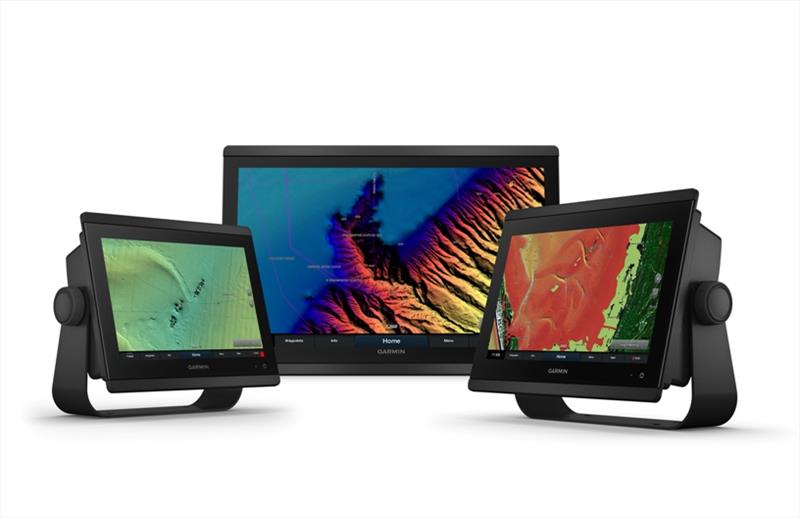
Garmin expands high-resolution relief shading chart coverage for new European countries © Garmin
Garmin® International, Inc., a unit of Garmin Ltd. (NASDAQ:GRMN), today announced expanded high-resolution relief shading coverage for the U.K., Ireland, Belgium, France, Germany, the Netherlands and Norway.
Coastal boaters and anglers in these regions, including Australia and New Zealand, can now download relief shading chart content to exclusive BlueChart® g3 Vision cartography products for an easy-to-interpret, clear view of the ocean floor.
"We remain committed to delivering the most detailed, accurate charts and maps for all of our customers across the globe, which is why we are pleased to offer high-resolution relief shading for our customers in Europe, New Zealand and Australia" said Dan Bartel, Garmin vice president of global consumer sales. "By blending Garmin and Navionics data in our cartography content, everyone from leisure boaters to serious divers and anglers will discover the difference of high-resolution relief shading for their on the water experience and situational awareness when navigating the coasts."
Relief shading combines rich colour and shadow, created from multibeam surveys and high-definition data, for a multidimensional illustration of bottom structure. Now, customers in European countries, New Zealand and Australia can download high-resolution relief shading directly to BlueChart g3 Vision cards, via the ActiveCaptain® app, in search of fish-holding structures, artificial reefs, underwater shelves or flat fishing spots. The ActiveCaptain app provides a simple yet powerful way to access this new chart layer and manage your marine experience, on top of other valuable functions such as the connected ActiveCaptain community.
Premium BlueChart g3 Vision cards offer a full suite of Garmin's latest g3 cartography, including features like blended Garmin and Navionics data and content, built-in Auto Guidance(1) technology, unique 3-D views and more. For unrivalled fishing chart detail and the best situational awareness on the water, BlueChart g3 Vision card owners also features 1-foot contours that can be overlaid on top of the high-resolution relief shading for a more accurate depiction of bottom structure.
High-resolution relief shading is now available for download to BlueChart g3 Vision cards in the U.K., Ireland, Belgium, France, Germany, the Netherlands, Norway, New Zealand and Australia. Existing customers with BlueChart g3 or BlueChart g3 Vision cards can update charts to view high-resolution relief shading and to ensure they have the latest data available from the 2021.0 cartography release. Learn more about Garmin marine charts and maps here.
Engineered on the inside for life on the outside, Garmin products have revolutionised life for anglers, sailors, mariners and boat enthusiasts everywhere. Committed to developing the most sophisticated marine electronics the industry has ever known, Garmin believes every day is an opportunity to innovate and a chance to beat yesterday. For the fifth consecutive year, Garmin was recently named the Manufacturer of the Year by the National Marine Electronics Association (NMEA). Other Garmin marine brands include Fusion® and Navionics®.
For more information, visit www.garmin.com
1 Auto Guidance is for planning purposes only and does not replace safe navigation operations.
2 Based on 2019 reported sales.