
Garmin introduces next-gen ECHOMAP Ultra 2 series
by Garmin 24 Oct 2023 16:58 BST
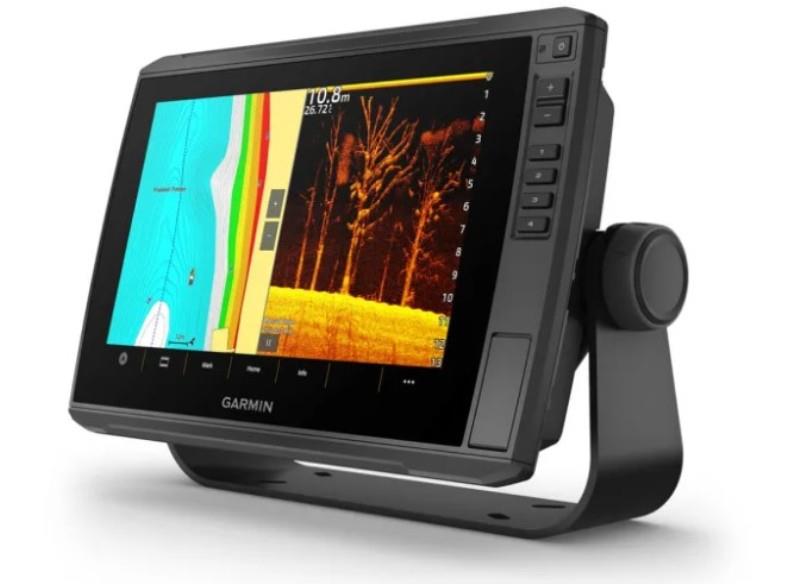
ECHOMAP Ultra 2 10` Chartplotters © Garmin
Garmin (NYSE: GRMN), the world's most innovative and recognised marine electronics manufacturer, today announced the ECHOMAP™ Ultra 2 chartplotter series designed with advanced features for inland and nearshore anglers.
Offering a 10- or 12-inch sunlight-readable touchscreen with keyed assist, they put UHD scanning sonar, support for Garmin Navionics+™ and Garmin Navionics Vision+ mapping with an included 1-year subscription for daily updates, wireless networking capabilities and more at an angler's fingertips.
"Professional anglers and weekend warriors alike have for years relied on the ECHOMAP Ultra series to provide superior sonar and mapping with a touchscreen design that can be quickly installed and removed from the boat at the end of the day. With the addition of wireless networking, multi-band GPS and a new user interface, the new ECHOMAP Ultra 2 series is even more versatile and easier to use than before." -Dan Bartel, Garmin Vice President of Global Consumer Sales
Combining power and functionality, the ECHOMAP Ultra 2 series will meet the demands of today's angler with exciting new features, including:
- Wireless Networking: Share sonar1, waypoints and routes with another ECHOMAP Ultra 2 or ECHOMAP UHD2 chartplotter on the boat, reducing the need to drill extra holes in the boat, while also keeping the deck space free from the clutter of extra cables.
- Position Accuracy: Multi-band GPS technology with fast 10Hz updates not only provides improved position accuracy, which can benefit anglers particularly in areas like under bridges, along bluffs or in coves with tree cover.
- Screen Recording: Using the ActiveCaptain® app, capture what's on the chartplotter screen, including fish catches seen on LiveScope™ sonar (if installed) to share via text or social media.
- Ease of Use: Featuring a modernised operating system with updated graphics, menus and a new homepage, anglers will appreciate how intuitive and easy-to-use the Ultra 2 series is.
For nearly photographic images of fish and structure, the Ultra 2 chartplotters are available bundled with a GT56UHD all-in-one transducer that provides Garmin CHIRP traditional sonar and Ultra High-Definition ClearVü™ and SideVü™ scanning images of what's below and to the sides of the boat. The new series also supports the full lineup of Garmin's award-winning LiveScope live-scanning sonar.
Available in two sizes, the ECHOMAP Ultra 2 102sv with a 10-inch display and ECHOMAP Ultra 2 122sv with a 12-inch display, the new series offers unparalleled mapping coverage and detail for both coastal and inland waters with support for optional Garmin Navionics+. In addition to the included 1-year subscription for daily updates, Garmin Navionics+ also offers depth range shading and Auto Guidance+2 for faster route calculation speeds of suggested pathways. Anglers can also upgrade to Garmin Navionics Vision+™ premium mapping, which offers high-resolution relief shading and more. To instantly create personalised fishing maps, the series also includes built-in Quickdraw Contours™ mapping software to deliver HD maps with 0,5 m contours on any body of water.
When wirelessly integrated with a Garmin Force® trolling motor, anglers can create routes, patterns and tracks for the trolling motor to follow while they fish. From the chartplotter screen, they can also control speed, check battery life and more.
See how the ECHOMAP Ultra 2 series can help you tell a new fish story.
Expected to be available next month, the ECHOMAP Ultra 2 chartplotters include a quick-release mount for fast and easy mobility, and they are sold with or without a GT56UHD-TM transducer. Suggested retail prices ranging from £1939.99 to £3079.99. To learn more, visit garmin.com/marine.
1 LiveScope sonar cannot be shared wirelessly between two ECHOMAP Ultra 2 or ECHOMAP UHD2 chartplotters.
2 Auto Guidance+ is for planning purposes only and does not replace safe navigation operations.