Edition


Tools for Setting Marks for Yacht Races |
Post Reply 
|
| Author |
 Printable Version Printable Version Delicious Delicious Digg Digg Facebook Facebook Furl Furl Google Google MySpace MySpace Newsvine Newsvine reddit reddit StumbleUpon Translate StumbleUpon Translate Twitter Twitter Windows Live Windows Live Yahoo Bookmarks Yahoo Bookmarks Topic Search Topic Search  Topic Options Topic Options
|
Laser3 
Newbie 

Joined: 18 Aug 19 Location: Jervis Bay Online Status: Offline Posts: 9 |
 Post Options Post Options
 Quote Reply Quote Reply
 Topic: Tools for Setting Marks for Yacht Races Topic: Tools for Setting Marks for Yacht RacesPosted: 19 Aug 19 at 5:37pm |
|
I have developed a New Free WebApp tool to help race officers set up the marks for yacht races. You simply enter the wind direction and the windward leg length, and the tool provides the bearings and back- bearings for all Marks => for Both Triangle and Trapezoid courses. Another option provides lat/longs for all Marks after the user clicks a Geolocation button at the bottom mark as the reference point. No more fiddly tables.
I would like to get some feed-back on it. See https://www.setcourses.com some examples Triangle LatLong => http://www.setcourses.com/triangle_latlong.html Simple Triangle 60-60-60 => https://www.setcourses.com/triangle60.html Trapezoid Lat/Long => http://www.setcourses.com/trapezoid_latlong.html Cheers John 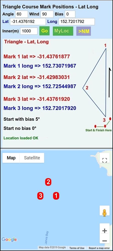 Edited by Laser3 - 19 Aug 19 at 6:53pm |
|
 |
|
|
davidyacht
Really should get out more 
Joined: 29 Mar 05 Online Status: Offline Posts: 1345 |
Post Options
Quote Reply
Posted: 19 Aug 19 at 6:33pm |
|
How do you get the app to try out?
|
|
|
Happily living in the past
|
|
|
|
|
Laser3
Newbie
Joined: 18 Aug 19 Location: Jervis Bay Online Status: Offline Posts: 9 |
Post Options
Quote Reply
Posted: 19 Aug 19 at 6:44pm |
|
It is a Web App which is accessed via the website (it is designed for mobiles)
some examples Triangle LatLong => http://www.setcourses.com/triangle_latlong.html Simple Triangle 60-60-60 => https://www.setcourses.com/triangle60.html Trapezoid Lat/Long => http://www.setcourses.com/trapezoid_latlong.html |
|
|
|
|
Gordon 1430
Far too distracted from work 
Joined: 27 Jun 17 Location: Lee on Solent Online Status: Offline Posts: 310 |
Post Options
Quote Reply
Posted: 20 Aug 19 at 8:13am |
|
Hi Laser3 Does it off set for tide, if not it wont be much use on any sea venues as that's the tricky bit to calculate. most race teams for events use GPS on the ribs to ping the committee boat and then work the distance and angle from that. The distance for the windward mark is often worked out from the speed tables for the Olympic classes and working around whatever boats your setting for. For a 400 use 470 for a 2000 use laser radial as a rough guide. I will send a link to a National race officer friend for his opinion. Cheers Gordon
|
|
|
Gordon
Phantom 1430 |
|
|
|
|
Laser3
Newbie
Joined: 18 Aug 19 Location: Jervis Bay Online Status: Offline Posts: 9 |
Post Options
Quote Reply
Posted: 20 Aug 19 at 9:42am |
|
Thanks for that.
Cheers
|
|
|
|
|
Laser3
Newbie
Joined: 18 Aug 19 Location: Jervis Bay Online Status: Offline Posts: 9 |
Post Options
Quote Reply
Posted: 20 Aug 19 at 6:23pm |
|
The Bias box could be used for tides.
For regattas we have three boats for management. If the race officer (RO) decides there needs to be a course change for a Triangle course, due to a wind shift, he radios the new upwind bearing. All three boast adjust their setcourses tool setting. Boat1 moves the upwind mark using the new back bearing and RO checks the bearing => 'drop'. Boat2 moves the wing mark using the new bearings. RO and Boat1 check => 'drop'. We use bearings rather than lat/longs as we only have 2 GPS units (!!) and changing lat/longs is fiddly. Cheers.
Edited by Laser3 - 20 Aug 19 at 6:25pm |
|
|
|
|
Laser3
Newbie
Joined: 18 Aug 19 Location: Jervis Bay Online Status: Offline Posts: 9 |
Post Options
Quote Reply
Posted: 30 Aug 19 at 9:25pm |
|
I have developed a MAP version draft. It needs a Smartphone with GPS - which I don't have (!!) and so I need some one to give it a try and to provide some feedback This tool provides a virtual GPS unit for Laying the Marks. => Enter the Lat Long for the Reference Location Mark 3 or click RefLoc to set it for your location. => Enter the windward direction and your preferences for the reach angle and leg length, Then Click GO. => This will display a map showing the Mark layout and their positions. =>Then, to set a mark, proceed in its direction. Click the ShowMyLoc button to show your current position as a 'dot'. Click it again and your new position will be plotted. Click GO to clear the 'dots' => If you need to relocate the marks due a wind shift, without moving the bottom reference mark (Mark 3), then simply enter the new direction and the altered position of the marks will be displayed.>To change the reference, either enter its new location, or go there and click MyLoc to reset all the course marks. =>Note: Click MyLoc and ShowMyLoc buttons twice for better accuracy => A Smartphone with GPS is required for accurate positions.
|
|
|
|
|
Post Reply
|
| Forum Jump | Forum Permissions You cannot post new topics in this forum You cannot reply to topics in this forum You cannot delete your posts in this forum You cannot edit your posts in this forum You cannot create polls in this forum You cannot vote in polls in this forum |
Bulletin Board Software by Web Wiz Forums® version 9.665y
Copyright ©2001-2010 Web Wiz
Change your personal settings, or read our privacy policy
Copyright ©2001-2010 Web Wiz
Change your personal settings, or read our privacy policy