Edition


Boats for sale
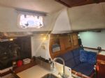
| Bruce Roberts classic 45 Valencia, Spain |
 |
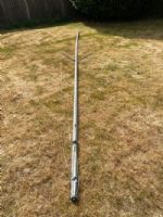
| Free mast for Merlin Rocket - has a bend! Guildford |
 |
| Rossiter Pintail Mortagne sur Gironde, near Bordeaux |
 |
List classes of boat for sale |


Techy help- GPS |
Post Reply 
|
| Author |
 Printable Version Printable Version Delicious Delicious Digg Digg Facebook Facebook Furl Furl Google Google MySpace MySpace Newsvine Newsvine reddit reddit StumbleUpon Translate StumbleUpon Translate Twitter Twitter Windows Live Windows Live Yahoo Bookmarks Yahoo Bookmarks Topic Search Topic Search  Topic Options Topic Options
|
alstorer 
Really should get out more 

Joined: 02 Aug 07 Location: Cambridge Online Status: Offline Posts: 2899 |
 Post Options Post Options
 Quote Reply Quote Reply
 Topic: Techy help- GPS Topic: Techy help- GPSPosted: 08 Apr 11 at 11:27am |
|
so, in a bonus powered shopping git I bought myslef one of these Oregoon Scientific ATC9K with a GPS module. I've been trying it out on my bike commuting this week, and I'll attach it to the boat this weekend. Picture quality seems good. In the software, the GPS mapping is good.
There's a "but" though. The GPS files seem to be in a proprietry format. I'd like to be able to use a site such as mapmytracks.com, but the .map file format is not recognised, and opening the files in notepad just gives gobbledygook, not a nice set of comma seperated values.
Anyone clever enough to be able to help? I've tried all sorts of google searches and not got anywhere.
If it would help, I can send the technically gifted an example file after work- PM me an email address.
It's a shame, it's a nice little unit, if only they hadn't been boneheaded with their file format.
|
|
|
-_
Al |
|
 |
|
|
Guests
Guest Group 
|
Post Options
Quote Reply
Posted: 08 Apr 11 at 11:51am |
|
Looking at the link it says that the GPS files will go into google earth so they're probably in KML format (or KMZ which is KML zipped).
mapmytracks wants GPX files. So it would seem that a file converter is needed.
Just done a quick google and there are some free ones available, I don't know what they're like though.
Dunno if that helps Edited by GK.LaserII - 08 Apr 11 at 1:42pm |
|
|
|
|
alstorer
Really should get out more
Joined: 02 Aug 07 Location: Cambridge Online Status: Offline Posts: 2899 |
Post Options
Quote Reply
Posted: 08 Apr 11 at 12:58pm |
|
Cheers- they definitely have the unhelpful extension .map, though they may be a renamed kml/kmz, I'll try renaming one and see if that sheds any light.
|
|
|
-_
Al |
|
|
|
|
Guests
Guest Group
|
Post Options
Quote Reply
Posted: 08 Apr 11 at 1:14pm |
|
.map files are associated with maps not tracklogs or so I thought....sounds a bit odd. The Oregon link def says the tracks are openable in google earth /google maps. Give it a go, if they do open in google you should then be able to save them as KMZ or KML. Edit;It's a right pain when they use "inovative" ideas with the file types, just had a similar problem with a waterproof video camera.
Just edited my above post it should of said GPX files for mapmytracks Edited by GK.LaserII - 08 Apr 11 at 1:44pm |
|
|
|
|
Post Reply
|
| Forum Jump | Forum Permissions You cannot post new topics in this forum You cannot reply to topics in this forum You cannot delete your posts in this forum You cannot edit your posts in this forum You cannot create polls in this forum You cannot vote in polls in this forum |
Bulletin Board Software by Web Wiz Forums® version 9.665y
Copyright ©2001-2010 Web Wiz
Change your personal settings, or read our privacy policy
Copyright ©2001-2010 Web Wiz
Change your personal settings, or read our privacy policy