Edition


-(1)-202408140552.gif)


Boats for sale
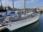
| Rossiter Pintail Mortagne sur Gironde, near Bordeaux |
 |
| Laser 28 - Excellent example of this great design Hamble le rice |
 |
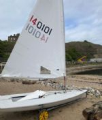
| Laser 140101 Tynemouth |
 |
List classes of boat for sale |


iPhone and Course Setting |
Post Reply 
|
Page 12> |
| Author |
 Printable Version Printable Version Delicious Delicious Digg Digg Facebook Facebook Furl Furl Google Google MySpace MySpace Newsvine Newsvine reddit reddit StumbleUpon Translate StumbleUpon Translate Twitter Twitter Windows Live Windows Live Yahoo Bookmarks Yahoo Bookmarks Topic Search Topic Search  Topic Options Topic Options
|
davidyacht 
Really should get out more 
Joined: 29 Mar 05 Online Status: Offline Posts: 1345 |
 Post Options Post Options
 Quote Reply Quote Reply
 Topic: iPhone and Course Setting Topic: iPhone and Course SettingPosted: 23 Oct 14 at 9:38am |
|
Has anyone used an iPhone to set courses.
I am looking to measure out .7 mile windward leg and it would be great to be able to drive up the beat at a bearing and drop the mark against a set distance.
Even better would be something that works out the wing mark position based on an angle and guides me in. I guess that there may be some apps that do this in a different application, orienteering maybe? Any suggestions greatly recieved. If it does not exist, it could be a useful app to develop. Otherwise I shall resort to traditional methods. |
|
 |
|
|
jeffers
Really should get out more

Joined: 29 Mar 04 Location: United Kingdom Online Status: Offline Posts: 3048 |
Post Options
Quote Reply
Posted: 23 Oct 14 at 9:42am |
|
There may be an app, you could probably use something like RunKeeper or similar to get the distance. As wind direction is constantly shifting going using a bearing might not work too well.
|
|
|
Paul
---------------------- D-Zero GBR 74 |
|
|
|
|
gordon1277
Really should get out more
Joined: 24 Mar 10 Location: United Kingdom Online Status: Offline Posts: 665 |
Post Options
Quote Reply
Posted: 23 Oct 14 at 9:47am |
|
The RYA have a deal on a garmin gps which will do the job and waterproof so less nerve racking!
|
|
|
Gordon
Lossc |
|
|
|
|
davidyacht
Really should get out more
Joined: 29 Mar 05 Online Status: Offline Posts: 1345 |
Post Options
Quote Reply
Posted: 23 Oct 14 at 9:50am |
|
Thanks Jeffers, I am less concerned about wing mark position, since can usually set this up by a bearing, and eye, but thought an app where you track up wind, clock your position, then homes you into a wingmark position based on distance and bearing, would be quite a useful tool, without having to buy and set up a GPS unit. Might be able to use Ski Tracks for the distance though not a lot of vertical (I hope)!
We don't run a lot of sea meetings and historically we have set things up by eye, this tends to produce very long beats ... hey I am in the committee boat so the pain does not matter! |
|
|
|
|
RTFM
Groupie 
Joined: 23 Nov 10 Online Status: Offline Posts: 41 |
Post Options
Quote Reply
Posted: 23 Oct 14 at 10:36am |
|
The iphone app iYachtRace
https://itunes.apple.com/hk/app/iyachtrace/id453236524?mt=8 Is worth maybe a look at...
|
|
|
Nobby.
|
|
|
|
|
davidyacht
Really should get out more
Joined: 29 Mar 05 Online Status: Offline Posts: 1345 |
Post Options
Quote Reply
Posted: 23 Oct 14 at 10:56am |
|
Hi Mark,
If it works this would be ideal, have contacted them ref compatibility with iphone 4
|
|
|
|
|
Brass
Really should get out more
Joined: 24 Mar 08 Location: Australia Online Status: Offline Posts: 1151 |
Post Options
Quote Reply
Posted: 23 Oct 14 at 1:13pm |
|
No doubt someone could develop an app if they could be bothered.
We recently had a thread about using GPS for mark-laying in the Race Management forum The basic functions required were in this post Meanwhile, what you seem to be wanting is a GPS-like display that will enable you to navigate to a Bearing and Distance from a Reference Point I presume there are plenty of basic GPS Apps for iphone. All you need is is PING Waypoint GO TO Waypoint Display with Bearing and Distance to Waypoint Simplest way to do it is to PING the RC Vessel (or other Reference Point designated by the RO), then use the Reciprocal Bearing to that waypoint and the required distance. You can, if you wish use Project Waypoints and the Sequential Waypoints method, but I find that a PIA in a mark-boat: just one PING and GO TO, using Reciprocal Bearing is by far the simplest The RYA provides ready reckoner tables with the bearing and distance from the Reference Point to the Wing Mark for Trap and Triangle courses. 70 Degree Trap and 60 Degree Triangles are really easy using Common Reference Point 70 Degree Trap, Distance to the OW mark equals the Distance to the IW mark, and Bearing (from Reference Point (IL, or Centre of SL) is Bearing of Windward Leg minus 40 degrees. 60 Degree Triangle, Distance to OW equals the Distance to the IW mark, and Bearing is Bearing of Windward Leg minus 60 degrees. Other combinations use the Ready Reckoners.
|
|
|
|
|
tgruitt
Really should get out more

Joined: 02 Dec 04 Online Status: Offline Posts: 2479 |
Post Options
Quote Reply
Posted: 23 Oct 14 at 1:17pm |
|
What does PING stand for?
|
|
|
Needs to sail more...
|
|
|
|
|
Brass
Really should get out more
Joined: 24 Mar 08 Location: Australia Online Status: Offline Posts: 1151 |
Post Options
Quote Reply
Posted: 23 Oct 14 at 1:48pm |
|
It's not an acronym: it's a noise.
A GPS is a machine that goes PING. To Ping an object is to use a GPS functionality to MARK, or RECORD CURRENT POSITION AS Waypoint.
|
|
|
|
|
tgruitt
Really should get out more
Joined: 02 Dec 04 Online Status: Offline Posts: 2479 |
Post Options
Quote Reply
Posted: 23 Oct 14 at 2:09pm |
|
Ah ok thanks. I've never heard one go ping before, unless my microwave is GPS enabled?

|
|
|
Needs to sail more...
|
|
|
|
|
Post Reply
|
Page 12> |
| Forum Jump | Forum Permissions You cannot post new topics in this forum You cannot reply to topics in this forum You cannot delete your posts in this forum You cannot edit your posts in this forum You cannot create polls in this forum You cannot vote in polls in this forum |
Bulletin Board Software by Web Wiz Forums® version 9.665y
Copyright ©2001-2010 Web Wiz
Change your personal settings, or read our privacy policy
Copyright ©2001-2010 Web Wiz
Change your personal settings, or read our privacy policy